Burkina Faso
This article is licensed under the GNU Free Documentation License. It uses material from the Wikipedia article "Berkina Faso". Map Courtesy CIA World Factbook
Formerly called Upper Volta, it was renamed on August 4, 1984 by President Thomas Sankara to mean "the land of upright people" (or "upright land") in Mossi and Dioula, the major native languages of the country. Independence from France came in 1960. Governmental instability during the 1970s and 1980s was followed by multiparty elections in the early 1990s. Several hundred thousand farm workers migrate south every year to Côte d'Ivoire and Ghana. The inhabitants of Burkina Faso are called Burkinabe. The capital is Ouagadougou, referred to by locals as "Ouaga." Like all of the west of Africa, Burkina Faso was populated early, notably by hunter-gatherers in the north-western part of the country (12 000 to 5000 BC), and whose tools (scrapers, chisels and arrowheads) were discovered in 1973. Settlements appeared between 3600 and 2600 BC with farmers, the traces of whose structures leave the impression of relatively permanent buildings. The use of iron, ceramics and polished stone developed between 1500 and 1000 BC, as well as a preoccupation with spiritual matters, as shown by the burial remains which have been discovered. Relics of the Dogon are found in the centre-north, north and north west region. They left the area between the 15th and 16th centuries BC to settle in the cliffs of Bandiagara. Elsewhere, the remains of high walls are localised in the south west of Burkina Faso (as well as in the Côte d'Ivoire), but the people who built them have not yet been definitely identified. Burkina Faso was an important economic region for the Songhai Empire during the 15th and 16th centuries. In 1896, the Mossi kingdom of Ouagadougou became a French protectorate after being defeated by French forces. In 1898, the majority of the region corresponding to Burkina Faso today was conquered. In 1904, these territories were integrated into French West Africa in the heart of the Upper-Senegal-Niger (Haut-Sénégal-Niger) colony. Its inhabitants participated in the First World War in the heart of the battalions of the Senegalise Infantry (Tirailleurs sénégalais). It was originally administered as part of Côte d'Ivoire colony, but became a separate colony in 1919. On March 1 1919, François Charles Alexis Édouard Hesling became the first governor of the new colony of Upper-Volta, which was broken up September 5 1932, being shared between the Côte d’Ivoire, Mali and Niger. On September 4 1947 Upper-Volta was recreated with its 1932 boundaries. On December 11 1958, it achieved self-government, and became a republic and member of the Franco-African Community (La Communauté Franco-Africaine). Full independence was attained in 1960. Its first military coup occurred in 1966, then returned to civilian rule in 1978. There was another coup, led by Saye Zerbo in 1980, which in turn was overthrown in 1982.
A counter-coup was launched in 1983, which left Captain Thomas Sankara in charge. The current president is Blaise Compaoré, who came to power in 1987 after a coup d'état that killed Thomas Sankara. |
||||||||||
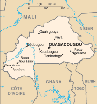 Burkina Faso is a landlocked nation of western Africa. It is surrounded by six countries. Mali to the north, Niger to the east, Benin to the south east, Togo and Ghana to the south, and Côte d'Ivoire to the south west.